
Red Rock Canyon sits just 20 minutes from the Strip, and it packs in some of the best desert hiking in the country. But show up without a plan and you’ll waste half your day at the visitor center parking lot, staring at a trail map that lists a dozen options with zero context. A solid red rock canyon hiking guide should tell you which trails actually match your fitness level and time budget, not just list names on a map.
This guide breaks down the trails that matter, from the easy Calico Tanks loop to tougher scrambles like Turtlehead Peak, with real distances, elevation gain, and how long each one actually takes to hike in summer heat versus cooler months.
We’ve guided thousands of visitors through this canyon since 2007, so we know which trails deliver the views worth the climb and which ones are skippable. Below you’ll find our picks for the best short hikes for families, the best half-day hikes for serious hikers, plus tips on parking reservations, water, and timing your hike around the sun. If a trail-and-map approach still sounds like too much legwork, our guided tours cover the highlights with a local expert doing the navigating for you.**
1. Calico Tanks Trail
Calico Tanks is the trail most first-time visitors end up on, and for good reason. It packs sandstone scrambling, a slot-like squeeze through boulders, and a payoff view of the Strip into a hike that most people finish in under two hours. If you only have time for one hike in Red Rock Canyon, this is the one locals recommend first.
Calico Tanks delivers the best view-to-effort ratio of any trail in Red Rock Canyon.
Distance and difficulty
The round trip runs about 2.2 miles with roughly 450 feet of elevation gain, and the National Park Service rates it moderate. The climb isn’t long, but the last quarter mile involves scrambling over loose rock and a narrow passage between boulders that trips up hikers in sandals. Budget 90 minutes to two hours for most fitness levels, longer if you stop often for photos.
| Metric | Detail |
|---|---|
| Distance | 2.2 miles round trip |
| Elevation gain | ~450 feet |
| Difficulty | Moderate |
| Typical time | 1.5-2 hours |
Trailhead and parking
You’ll start at the Sandstone Quarry parking area, roughly 2.5 miles into the 13-mile scenic loop drive. This lot fills up fast on weekends and holidays, so arriving before 9 a.m. matters more here than almost anywhere else in the park. Remember that Red Rock Canyon requires a timed-entry vehicle reservation for the scenic drive during peak season, which you book in advance through recreation.gov, so plan your parking window around that reservation rather than showing up and hoping for a spot.
What you’ll see on the trail
Early on, the path crosses open desert dotted with yucca and barrel cactus before climbing into a wash lined with red and cream-colored sandstone. About halfway up, you’ll pass the actual
2. Turtlehead Peak Trail
Turtlehead Peak is the trail you pick when Calico Tanks feels too easy. It’s the toughest maintained hike in Red Rock Canyon, climbing straight up a ridge to a summit that most visitors never attempt. Guides here call it the real test of the park, and the crowds thin out fast once the trail leaves the valley floor.
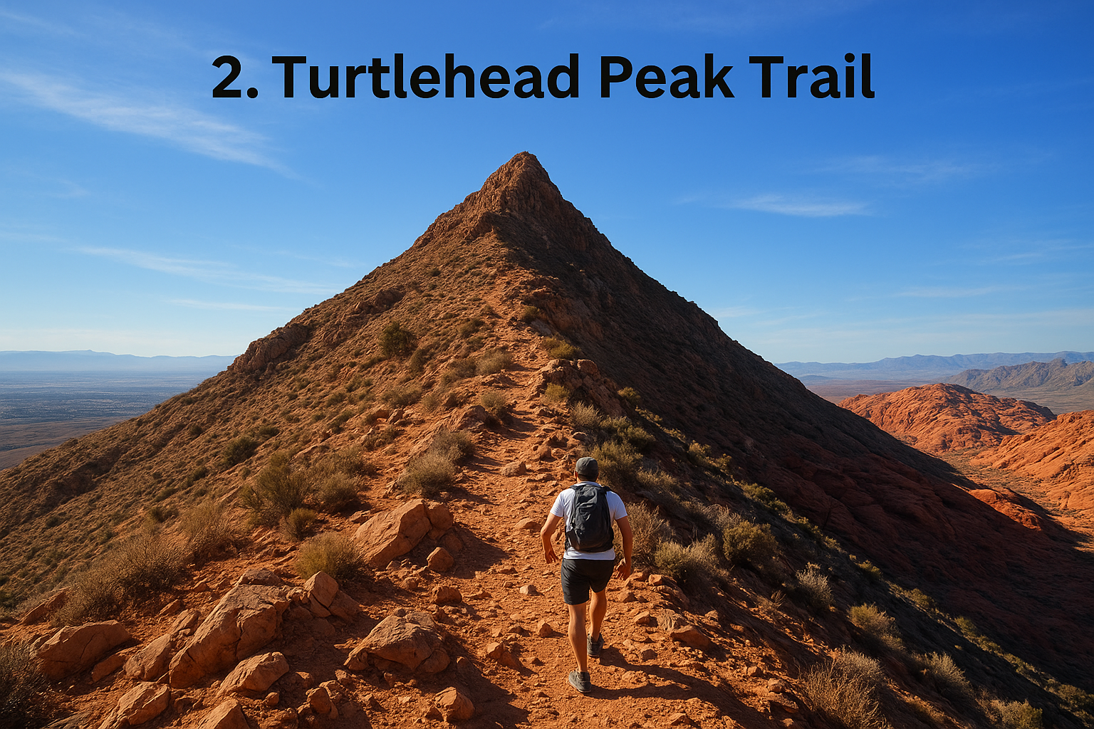
Turtlehead Peak separates casual hikers from the ones who came for a workout.
Distance and difficulty
Expect a 4.6-mile round trip with over 2,000 feet of elevation gain packed into the second half of the hike. The Park Service rates it strenuous, and that rating undersells the last mile, which turns into a scramble over loose scree with no shade. Most hikers need 3.5 to 4.5 hours, and this isn’t a trail to start after 10 a.m. in summer.
Trailhead and parking
You’ll park at the same Sandstone Quarry lot used for Calico Tanks, since both trails share the first stretch before splitting. That overlap means the lot fills even faster, so arrive at opening or plan for a wait during your reserved entry window. Bring more water than you think you need; there’s no refill point anywhere on this route.
What you’ll see on the trail
The trail climbs through desert scrub before the switchbacks start, and the views open up fast once you clear the first ridge. Near the top, the Las Vegas Valley spreads out on one side while the Calico Hills’ red sandstone stretches out on the other, a payoff few other hikes in the park can match.
Best for
This one suits fit, experienced hikers looking for a genuine summit push, not families or casual walkers. Skip it in July and August unless you’re starting before sunrise.
3. Ice Box Canyon Trail
Ice Box Canyon earns its name honestly. Tucked into a shaded ravine on the west side of the loop drive, it’s the coolest hike in the park on a hot afternoon, sometimes 15 degrees cooler than the open desert trails nearby. Hikers looking to escape the sun without giving up scenery gravitate here once they’ve done the popular routes.
Ice Box Canyon stays cool when every other trail in the park is baking.
Distance and difficulty
The out-and-back run is about 2.6 miles with roughly 400 feet of elevation gain, and the Park Service rates it moderate. The trail itself is rocky and uneven rather than steep, with several boulder-hop sections near the canyon’s end that slow hikers down. Plan on 1.5 to 2 hours, and wear shoes with real ankle support since loose rock covers most of the last half mile.
Trailhead and parking
Parking sits at the Ice Box Canyon trailhead, about 5.7 miles into the scenic loop drive, in a small lot that fills up by mid-morning on weekends. Unlike Calico Tanks or Turtlehead Peak, this trailhead rarely draws a crowd before 9 a.m., making it a good backup plan if the Sandstone Quarry lot is already full.
What you’ll see on the trail
Dense vegetation lines the wash early on, a sign of the water that occasionally flows through here after storms. Sheer canyon walls rise higher as you go deeper, eventually narrowing into a rocky dead end below a seasonal waterfall that only runs after rain. Photographers favor this spot for the contrast between the dark canyon shadows and the bright sandstone above.
Best for
Ice Box Canyon suits hikers chasing shade and quiet over big views or summit bragging rights. It works well for a midday hike in warmer months when other trails feel unbearable.
4. Pine Creek Canyon Trail
Pine Creek Canyon cuts into the base of Mescalito Peak, and it’s the trail locals send hikers to when they want ruins, running water, and canyon walls without the crowds that swarm Calico Tanks. Old stone foundations from a homestead sit near the wash, adding a bit of history most visitors never expect to find in the desert. It’s one of the more underrated stops in any thorough red rock canyon hiking guide.
Distance and difficulty
The main route runs about 3 miles round trip with 400 feet of elevation gain, and the Park Service rates it moderate. The trail splits into two forks near the canyon mouth, and the left fork toward the old homestead ruins is easy walking, while the right fork pushes deeper into the canyon over rougher, rockier ground. Most hikers finish in 1.5 to 2 hours, depending on which fork they follow and how long they linger at the ruins.
Pine Creek Canyon rewards hikers who take the extra ten minutes to detour toward the homestead ruins.
Trailhead and parking
You’ll find the Pine Creek Canyon trailhead about 8.5 miles into the scenic loop drive, with a lot that’s noticeably calmer than Sandstone Quarry’s. Weekday mornings almost always have open spots, and even weekends rarely fill before mid-morning.
What you’ll see on the trail
Cottonwood trees and seasonal streams shade the lower canyon, a sharp contrast to the open desert you drove through to get here. Sandstone cliffs rise on both sides as the trail climbs, framing Mescalito Peak’s distinctive profile ahead. Water pools in shaded pockets after rain, drawing birds and the occasional bighorn sheep.
Best for
Pine Creek suits hikers who want history and shade mixed into their scenery, plus anyone traveling with kids who still want a real canyon feel without a strenuous climb.
5. Kraft Mountain Loop Trail
Kraft Mountain sits outside the main scenic loop drive, tucked into Calico Basin, which means it skips the timed-entry reservation entirely. It’s a favorite among climbers and boulderers, but the loop itself works just as well for hikers who want a workout with a unique payoff: a natural sandstone arch you can walk right up to.
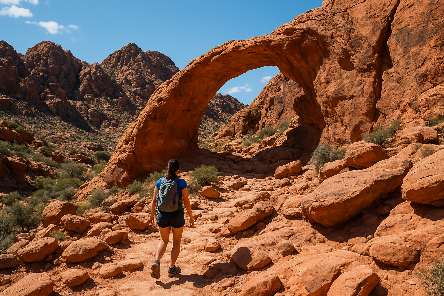
Kraft Mountain gives you a Red Rock hike without fighting the scenic drive reservation system.
Distance and difficulty
The full loop covers about 2.5 miles with roughly 600 feet of elevation gain, and most hikers call it moderate to strenuous depending on which direction they go. Sections of the trail require scrambling over slickrock without a defined path, so route-finding skills matter more here than on marked trails elsewhere in the park. Expect 1.5 to 2.5 hours, longer if you detour to the arch or stop to watch climbers on the surrounding walls.
Trailhead and parking
You’ll park in the Calico Basin lot, just off Calico Basin Road before you reach the main Red Rock Canyon entrance station. This lot fills quickly on weekends since it serves climbers, boulderers, and hikers alike, so weekday mornings are your best bet for an easy spot.
What you’ll see on the trail
Sandstone boulders and steep rock faces dominate the scenery here, with climbers scaling routes visible from the trail itself. Partway around the loop, a natural arch carved into the rock offers a shaded rest spot and a good photo stop before the trail continues its climb toward the ridge.
Best for
Kraft Mountain suits adventurous hikers comfortable with off-trail scrambling and anyone hoping to avoid the reservation system altogether. It’s not the trail for beginners or anyone uneasy on exposed rock.
6. White Rock and La Madre Spring Loop
The White Rock and La Madre Spring Loop covers more ground than most trails in the park, and it rewards hikers who want variety over a quick payoff view. You’ll cross open desert, climb into a shaded spring area, and skirt the base of white-streaked sandstone cliffs that give the trail its name. It’s a favorite for hikers who’ve already done Calico Tanks and want something longer without the scramble.
The White Rock and La Madre Spring Loop trades a fast payoff for a longer, more varied day in the desert.
Distance and difficulty
The full loop runs about 6.2 miles with roughly 700 feet of elevation gain, and the Park Service rates it moderate. The distance, not the climb, is what wears hikers down here, since the terrain stays relatively gentle outside a few rocky stretches near the spring. Plan on 3 to 4 hours, and start early if you’re hiking between May and September.
Trailhead and parking
You’ll start at the White Rock/Willow Springs trailhead, about 8.7 miles into the scenic loop drive, sharing a lot with the shorter Willow Springs Loop. Parking here is more forgiving than Sandstone Quarry, though weekend mornings still fill by mid-morning during cooler months.
What you’ll see on the trail
The first stretch crosses open desert with wide views of the surrounding cliffs before the trail bends toward La Madre Spring, a shaded oasis where cottonwoods and willows cluster around a reliable water source. Beyond the spring, the trail traces the base of pale, streaked cliffs that give the loop its name, offering a change of scenery from the red sandstone dominating most of the park.
Best for
This loop suits hikers who want mileage and variety over a short, dramatic climb. It’s a solid pick for cooler months when a longer hike doesn’t mean fighting the heat the whole way.
7. Keystone Thrust Trail
Keystone Thrust Trail gets overlooked by most visitors, but it’s the trail geology fans seek out first. It follows a genuine geological fault line where older gray limestone got pushed up and over younger red sandstone millions of years ago, and you can actually see the color contrast where the two rock layers meet. Few other spots in the park make plate tectonics this visible to the naked eye.
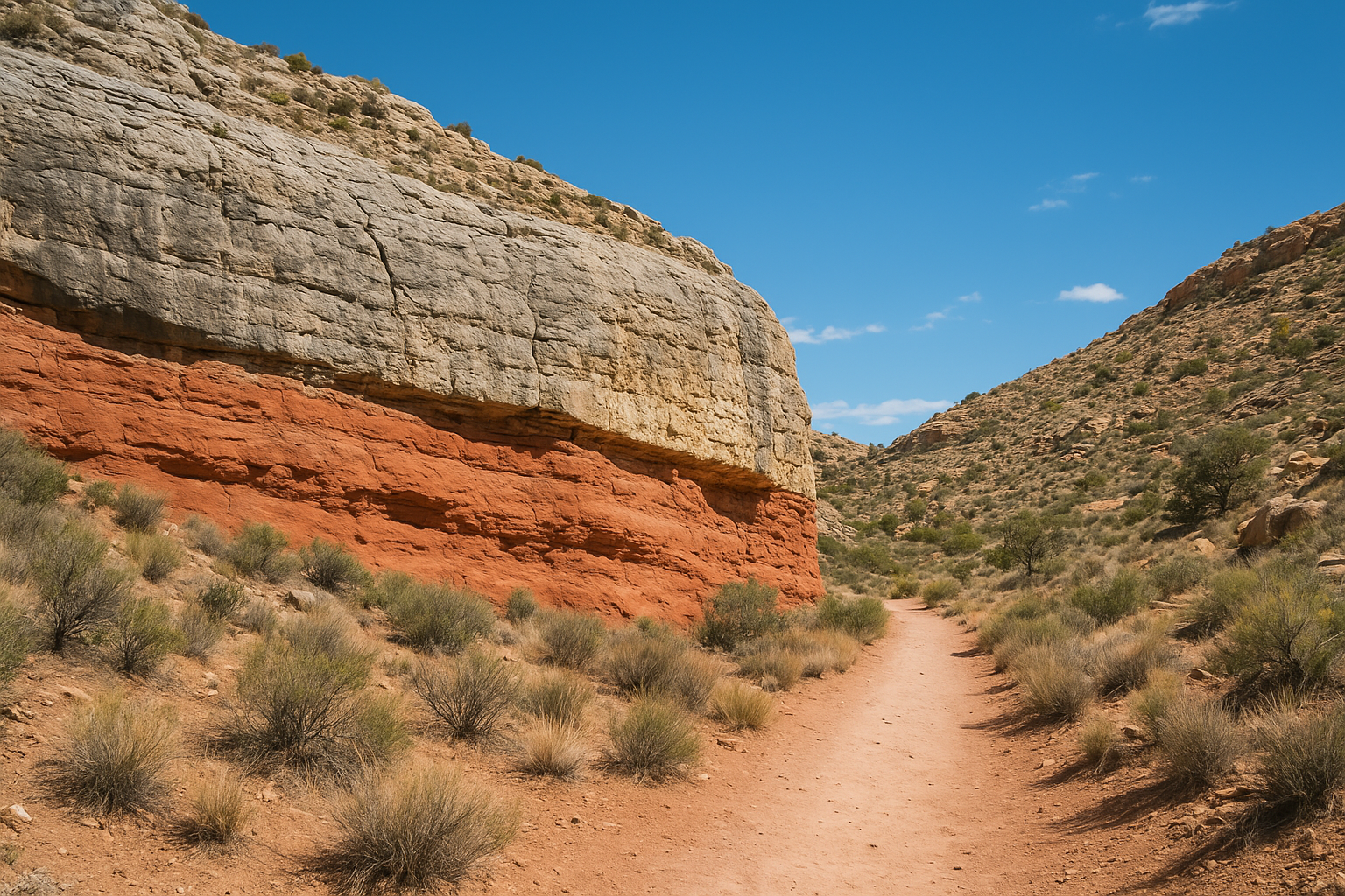
Keystone Thrust is the one trail in the park where you can put your hand on the actual fault line.
Distance and difficulty
The round trip covers about 2.5 miles with roughly 400 feet of elevation gain, and most hikers rate it easy to moderate. The path stays fairly gentle throughout, with only a short rocky stretch near the turnaround point where the fault becomes visible. Budget 1 to 1.5 hours, making this one of the shorter half-day options in the park.
Trailhead and parking
You’ll start from the same White Rock/Willow Springs lot used for the White Rock and La Madre Spring Loop, about 8.7 miles into the scenic drive. Since fewer hikers know about this trail, the walk itself sees noticeably less traffic than the parking lot might suggest.
What you’ll see on the trail
The trail crosses open desert flats before climbing gently toward a hillside where gray limestone sits stacked directly on top of red sandstone, a clear visual record of the thrust fault. Interpretive signage along the way explains what you’re looking at, which helps if you’re not a geology buff but still want to understand the significance.
Best for
Keystone Thrust suits curious hikers and families who want an easy walk with genuine educational value. It’s also a smart pick when you’re short on time but still want something more substantive than a paved overlook.
8. First Creek Canyon Trail to the Grotto
First Creek Canyon sits on the south end of the park, away from the scenic loop drive entirely, which makes it a smart pick when the main entrance station has a long line of cars waiting on a reservation. Water runs through this canyon more reliably than most others in Red Rock, feeding cottonwoods and willows that turn the trail green well into early summer. Hikers who want a shaded creekside walk without the crowds at Calico Tanks tend to end up here.
First Creek Canyon runs water and shade longer into the season than almost any other trail in the park.
Distance and difficulty
The hike to the Grotto runs about 2.9 miles round trip with roughly 300 feet of elevation gain, and most guides rate it easy to moderate. The path follows the creek bed loosely, crossing water a few times on rocks or logs depending on recent rainfall. Plan on 1.5 to 2 hours, with extra time if you want to sit at the pool near the Grotto itself.
Trailhead and parking
You’ll park at the First Creek trailhead, located off State Route 159 south of the main visitor center and outside the timed-entry reservation zone. This lot rarely fills before mid-morning, even on busy weekends, since fewer visitors realize the trail exists.
What you’ll see on the trail
Dense vegetation lines the wash for most of the hike, a rare sight against the dry desert flats you drive through to reach the trailhead. The canyon narrows near the end, opening into the shaded Grotto, a rock alcove with a seasonal pool that draws birds and the occasional bighorn sheep.
Best for
This trail suits hikers craving shade and water without a strenuous climb, plus anyone hoping to skip the reservation system altogether.
9. Calico Hills Trail
Calico Hills Trail winds through the same red sandstone formations that dominate every postcard shot of Red Rock Canyon, but without the crowds that pack the Calico Tanks lot. Instead of one clear route, you get a network of sandy paths weaving between rock domes, letting hikers pick their own line and turn back whenever they’ve had enough. It’s less a single trail than a choose-your-own-adventure through some of the park’s most photogenic terrain, which is why it shows up in nearly every serious red rock canyon hiking guide.
Distances vary depending on which paths you string together, but a typical loop runs 1.5 to 3 miles with minimal elevation gain, rarely more than 200 feet. The Park Service doesn’t post an official difficulty rating since routes vary so much, but most hikers call it easy. Expect 45 minutes to 90 minutes, longer if you wander off toward the base of the domes to watch climbers.
Calico Hills rewards hikers who’d rather explore freely than follow a single marked path.
Trailhead and parking
You’ll park at the Calico Hills lot, roughly 1.5 miles into the scenic loop drive, one of the smaller pullouts along the route. It fills quickly once the sun climbs, so weekday mornings or an early reserved entry window work best.
What you’ll see on the trail
Rounded sandstone domes rise on every side, streaked with iron oxide bands that shift color depending on the light. Sand pockets between the rocks make for easy walking, while sheer faces overhead draw climbers year-round.
Best for
Wanderers and photographers who want flexibility over structure will love this one. Families with younger kids also do well here, since you can shorten the walk anytime without missing a defined summit or endpoint.
10. Lost Creek Trail and Petroglyph Wall
Lost Creek Trail packs cultural history and a seasonal waterfall into one of the shortest walks in the park. It’s the trail to bring anyone who wants to see genuine petroglyphs carved by the people who lived here long before Las Vegas existed, and the short distance makes it easy to fit in even on a rushed schedule. Guides often pair this stop with Calico Tanks since both trailheads sit close together on the loop drive.
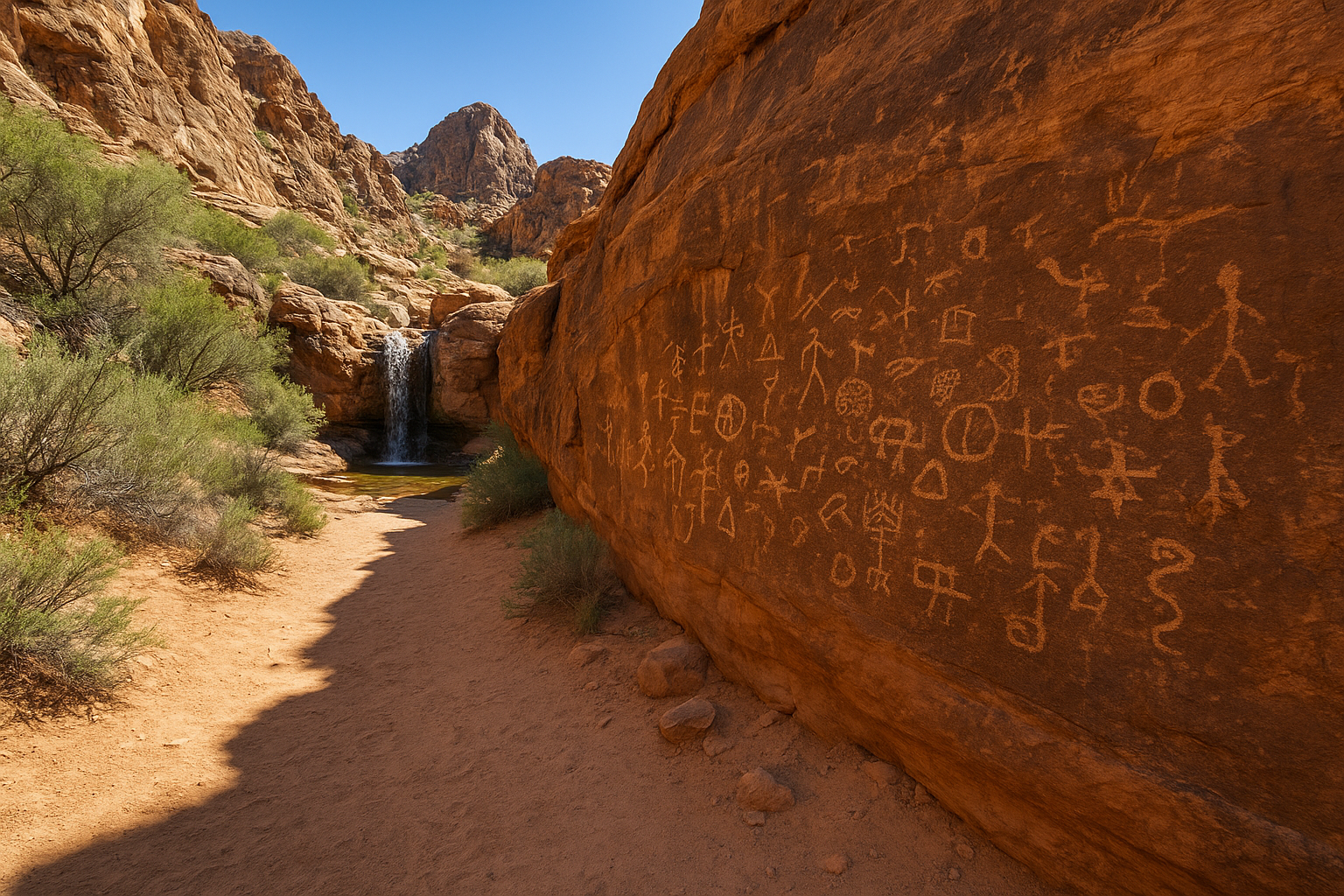
Lost Creek fits centuries of history into a walk shorter than most grocery runs.
Distance and difficulty
The round trip covers about 0.75 miles with barely any elevation gain, and the Park Service rates it easy. Flat, sandy terrain makes this one of the few trails in the park suitable for strollers or anyone unsteady on rock. Most visitors finish in 20 to 30 minutes, including time spent studying the petroglyph panel.
Trailhead and parking
You’ll find the Lost Creek trailhead about 2.5 miles into the scenic loop drive, close to the Sandstone Quarry lot used for Calico Tanks. The small dedicated lot fills quickly, but overflow parking along the road nearby usually keeps a spot within reach.
What you’ll see on the trail
A short walk through desert scrub leads to a sandstone wall covered in petroglyph carvings, faint but visible if you know where to look. Push a little farther and you’ll reach a seasonal waterfall that only flows after rain, framed by a small pool and towering canyon walls above it.
Best for
Lost Creek suits families, older visitors, and anyone short on time who still wants a genuine payoff. It also works well as a quick add-on to a longer hike elsewhere in the park.
11. Willow Springs Loop Trail
Willow Springs Loop packs a bit of everything into a short walk: rock art, historic graffiti, and desert scenery that changes character every few hundred feet. It’s a favorite for hikers who want a taste of the park’s history without committing to a longer trek, and it works well as a second stop after a bigger hike earlier in the day. Guides on our tours often use this loop to explain how much history sits in plain sight along an easy red rock canyon hiking guide favorite.
Willow Springs proves you don’t need mileage to find real history in this canyon.
Distance and difficulty
The full loop runs about 1.5 miles with minimal elevation gain, rarely more than 100 feet, and the Park Service rates it easy. Sandy paths and a short rocky section near the historic markers make up the toughest parts of the walk. Most hikers finish in 45 minutes to an hour, including stops to read the interpretive signs.
Trailhead and parking
You’ll park at the Willow Springs picnic area, roughly 8.7 miles into the scenic loop drive, sharing access with trails heading toward White Rock and La Madre Spring. Space here fills up on weekends, but the lot is larger than most along the drive, so finding a spot rarely takes long.
What you’ll see on the trail
Early on, the trail passes 1800s-era rock inscriptions left by pioneers and ranchers, alongside older petroglyphs carved by earlier inhabitants of the canyon. Farther along, desert scrub gives way to a small rock shelter that once offered shade to travelers crossing this stretch of desert.
Best for
This loop suits history buffs and casual walkers who want an easy add-on to a longer day of hiking. It’s also a smart pick for families looking for a short, flat walk with something genuinely interesting to point out along the way.
12. Red Spring Boardwalk Trail
Red Spring Boardwalk Trail closes out this list because it’s the easiest true hike in the park, and it’s the one you send anyone with mobility concerns or a stroller to without hesitation. A raised wooden boardwalk protects a fragile desert spring while still letting hikers get close enough to see water pooling year-round in the middle of dry sandstone. It’s proof you don’t need a strenuous climb to end a day of hiking on a genuine high note.
Red Spring proves the easiest trail in the park can still show you something worth the drive.
Distance and difficulty
The loop covers about 0.6 miles with essentially no elevation gain, and the Park Service rates it easy. Firm boardwalk sections make up most of the path, with only a short stretch of packed dirt connecting back to the parking lot. Most visitors finish in 20 to 30 minutes, longer if you linger at the overlook benches.
Trailhead and parking
You’ll park at the Red Spring picnic area, just past the entrance station near the start of the scenic loop drive. This lot stays busy since it’s one of the first stops drivers reach, but turnover happens fast because most visits run short.
What you’ll see on the trail
The boardwalk winds past desert willows and reeds clustered around the spring, a rare patch of green against the surrounding red sandstone cliffs. Overlook points along the way frame the Calico Hills in the distance, giving you a preview of the scenery waiting on longer trails nearby.
Best for
Red Spring suits families with strollers, older visitors, and anyone pressed for time who still wants real desert scenery. It also makes a solid first stop to get oriented before tackling a longer trail on the same visit.
Planning your Red Rock Canyon hike
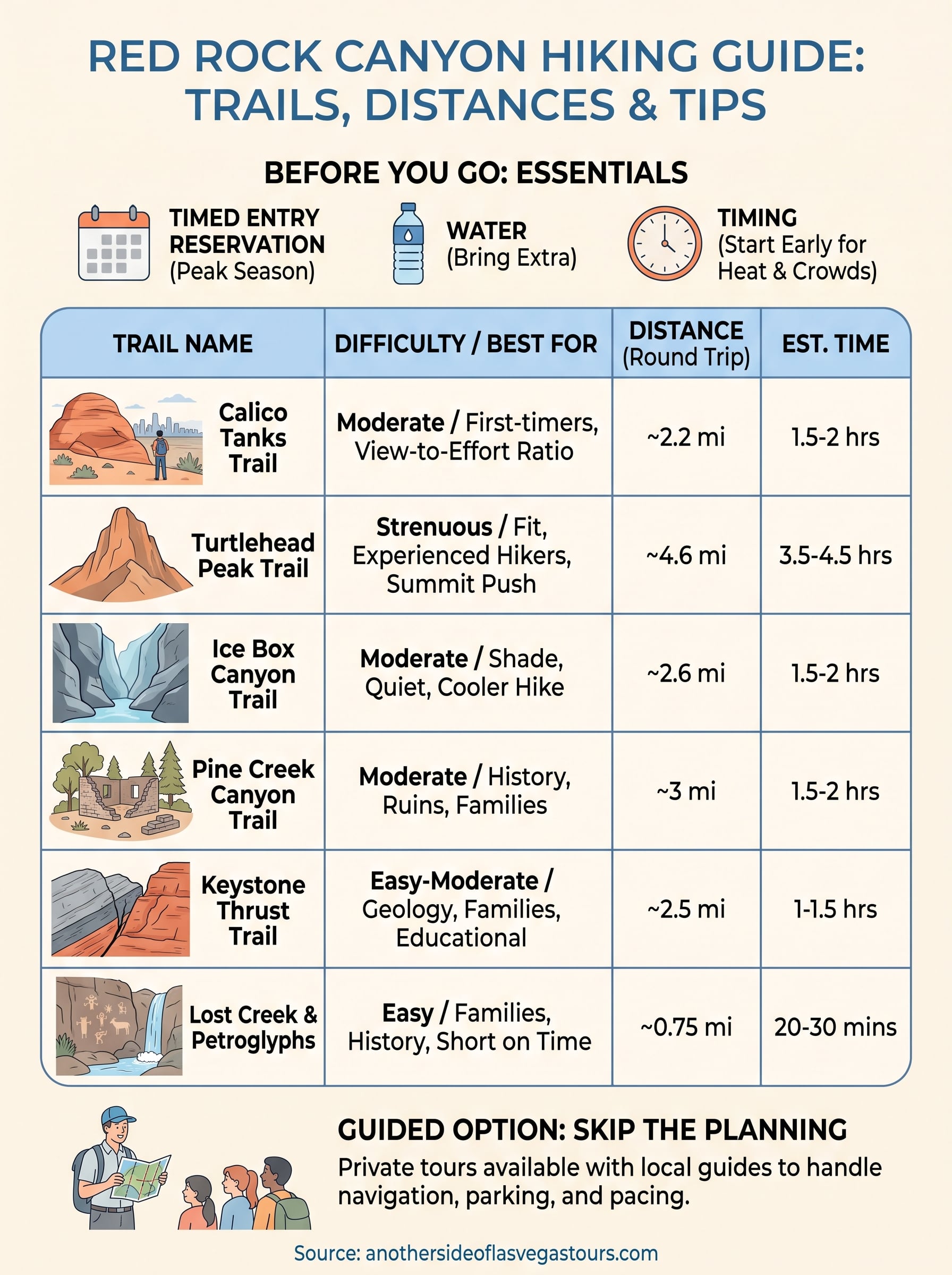
Twelve trails, one canyon, and no shortage of ways to spend a day here. Pick based on your fitness and your schedule, not just the photos you’ve seen online. Calico Tanks and Red Spring cover the casual crowd, Turtlehead Peak and Kraft Mountain handle the hikers who want a real workout, and everything in between fills the gaps for families, history buffs, and shade-seekers dodging the desert sun.
Before you go, lock in your timed-entry reservation, fill every water bottle you own, and start early enough to beat both the heat and the crowds. Loose rock and sun exposure catch more hikers off guard here than steep climbs do.
If you’d rather skip the planning and let someone else handle navigation, parking, and pacing, book one of our private tours and let a local guide walk you through the canyon’s best trails firsthand.