
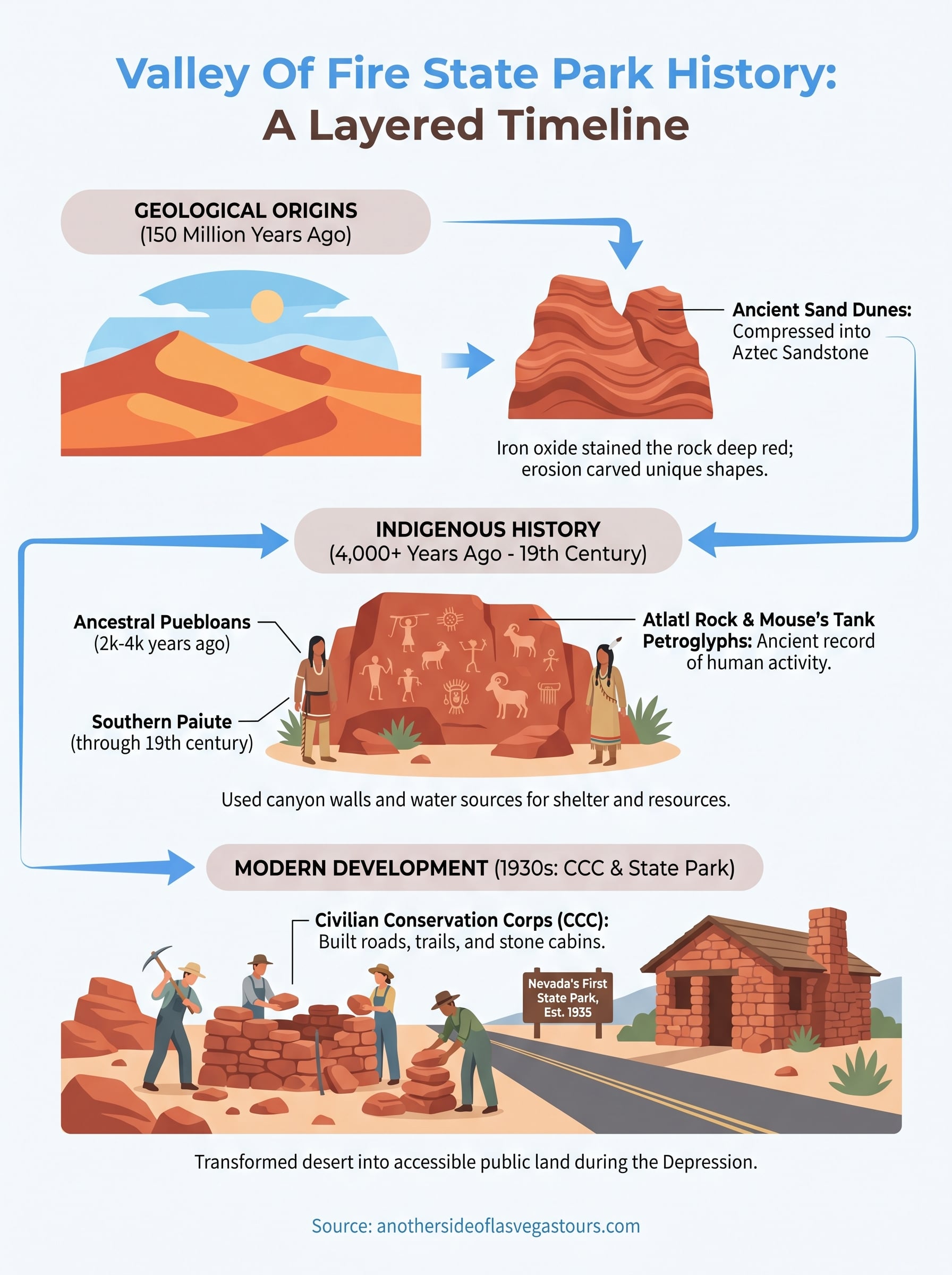
Valley of Fire sits about an hour northeast of the Las Vegas Strip, but it feels like a different planet. The red sandstone formations that define the park started taking shape roughly 150 million years ago, long before humans set foot in the Mojave Desert. Understanding the full Valley of Fire State Park history means going back to those ancient sand dunes, then forward through thousands of years of indigenous life, and finally to the 1930s, when the Civilian Conservation Corps built the infrastructure that made public access possible.
This park holds Nevada’s oldest designation as a state park, and its story is layered in ways most visitors never hear about on a quick photo stop. The petroglyphs carved into its walls, the geology exposed along its trails, and the CCC-era stonework still standing today all connect to distinct chapters worth knowing.
At Another Side Tours, we take guests from Las Vegas out to places like Valley of Fire with guides who know these stories firsthand. Below, we’ll walk through the geological origins of the park, the Native American communities who called it home, and the Depression-era workers who turned raw desert into one of the Southwest’s most striking protected spaces.
Why Valley of Fire history matters today
When you walk through Valley of Fire, you’re moving through multiple overlapping timelines at once. The red rock walls hold geological forces, ancient human hands, and Depression-era labor all in the same square mile. Most visitors spend an hour or two on the scenic loop without realizing that each stop carries a distinct historical layer worth understanding before you arrive. Knowing even the basics shifts the entire experience from sightseeing to something closer to reading.
The difference between a photo stop and a meaningful visit often comes down to context, and Valley of Fire has more context per square mile than almost anywhere in the Southwest.
The park as a layered record
Valley of Fire State Park history isn’t a single story. It spans Jurassic-era geology, thousands of years of indigenous presence, and a federal work program that turned raw desert into accessible public land during one of America’s hardest economic periods. Each chapter built on the last, and the physical evidence of all three is still visible if you know what you’re looking at. That depth is what separates this park from a scenic overlook.
Here’s what those layers include at a glance:
- Geological formation: Sandstone laid down roughly 150 million years ago
- Indigenous history: Petroglyphs and campsites spanning several thousand years
- Modern development: CCC construction in the 1930s that created the park’s original infrastructure
Why context changes your visit
You don’t need a background in geology or archaeology to benefit from knowing the basic historical framework of the park. What you gain is a reason to slow down at specific spots rather than moving through them quickly. The petroglyphs at Atlatl Rock, for example, stop being faded marks on stone once you understand who made them, why this location mattered, and how long ago they were carved.
How the Valley of Fire landscape formed
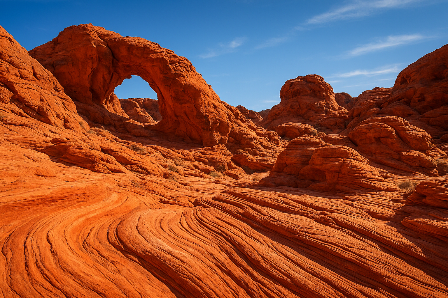
The terrain you walk through at Valley of Fire didn’t start as rock. Roughly 150 million years ago, during the Jurassic period, this region was covered by massive shifting sand dunes similar to what you’d find in the Sahara today. Over millions of years, those dunes compressed under their own weight and the pressure of sediment above them, eventually hardening into the Aztec Sandstone that defines the park’s signature red formations.
What turned sand into stone
Heat and mineral-rich groundwater did most of the work. As iron oxide seeped through the compressed sand, it stained the rock in the deep reds and oranges you see across the park today. Erosion over millions of years then carved out the arches, beehives, and wave-like ridges that make Valley of Fire look unlike almost anywhere else on Earth.
The colors aren’t a coating on the surface. They’re iron minerals baked into the rock over timescales that are hard to picture standing there in person.
Connecting this geology to valley of fire state park history matters because the landscape itself is what drew every group afterward to this stretch of desert. The sheltered canyon walls and reliable water sources created by that ancient geology made the area useful to humans for thousands of years.
Who lived here first: tribes, timelines, petroglyphs
Human presence at Valley of Fire stretches back at least 4,000 years. The Ancestral Puebloans were among the earliest documented groups here, followed by the Southern Paiute, who lived across this region through the time of European contact.
The groups who used this land
Both groups used the canyon walls and water sources as practical resources. The Ancestral Puebloans left campsites and tools dating back 2,000 to 4,000 years, while the Southern Paiute maintained a presence tied to seasonal movement across the Mojave.
The valley wasn’t empty desert. People lived, hunted, and sheltered here for thousands of years before any road crossed it.
- Ancestral Puebloans: roughly 2,000 to 4,000 years ago
- Southern Paiute: sustained presence through the 19th century
What the petroglyphs tell you
The petroglyphs at Atlatl Rock and Mouse’s Tank connect you directly to that human timeline in valley of fire state park history. These images include figures, animals, and symbols carved using stone tools over many centuries.
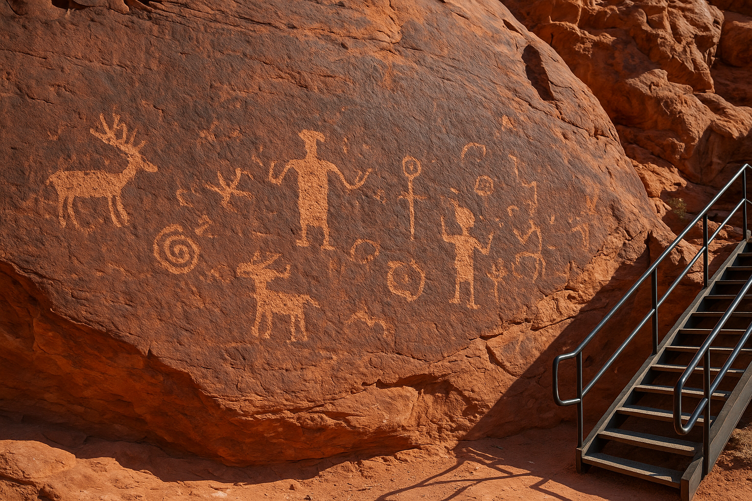
You can walk up to Atlatl Rock on a staircase and view the carvings directly. Few spots in the park put you this close to ancient human activity in such a raw, unmediated setting.
How travel routes shaped the area before the park
The valley didn’t become significant only when the state designated it. Long before any formal boundaries existed, this stretch of desert served as a transit corridor for traders and travelers moving across the Mojave. The geology that shaped valley of fire state park history also made the area a practical passage point, with canyon walls offering shade and water sources breaking up otherwise harsh terrain.
The Old Spanish Trail and what it meant
Running near this region, the Old Spanish Trail was one of the major overland trade routes of the early 19th century, carrying goods between Santa Fe and Los Angeles. Travelers used the valley’s natural rock formations as reference points across a landscape with few reliable landmarks.
The same geography that drew ancient people to this area continued pulling travelers through it centuries later, for exactly the same practical reasons.
Water and shelter determined where you stopped and where you pushed on through desert heat. Routes like this one established a pattern of human movement through the valley that predated any formal recognition of the land’s value, laying the groundwork for the eventual decision to protect and develop it as public space.
How it became Nevada’s first state park
Nevada designated Valley of Fire as its first state park in 1935, a decision driven by both the land’s visual significance and a growing push to preserve accessible public land. The Civilian Conservation Corps (CCC), a New Deal work program, played a central role in making that designation practical by building roads, trails, and the stone cabins you can still rent today.
What the CCC built and why it still matters
CCC crews arrived in the early 1930s and transformed largely inaccessible desert into a navigable park. They built stone structures using local Aztec Sandstone, which is why the buildings blend naturally into the landscape rather than looking imported. This chapter of valley of fire state park history ties the park’s physical infrastructure to a specific American moment, when federal programs put unemployed workers onto public lands to create lasting improvements.
The stone cabins at Valley of Fire weren’t just practical shelters. They’re standing proof of what the CCC accomplished across Nevada during the Depression.
Those structures have stood for nearly 90 years, and the original stonework remains largely intact, which reflects the craft the CCC workers brought to the job.
Final takeaways
Valley of Fire State Park history runs deeper than most visitors expect. The 150-million-year geological record, the petroglyphs left by the Ancestral Puebloans and Southern Paiute, and the CCC stonework from the 1930s all coexist within the same park boundaries. Each layer adds meaning to what you see when you’re standing in front of those red rock formations.
Knowing this history before you arrive changes how you move through the park. You’ll slow down at Atlatl Rock because you understand who carved it. You’ll notice the CCC-built cabins differently once you know the story behind them. Context turns a scenic drive into something far more substantial.
If you want to experience all of this with a guide who knows the details, our private Valley of Fire tours take you through the park with expert narration built into every stop, so nothing goes unexplained.